Bravo! Adventure
Gulf Crossing
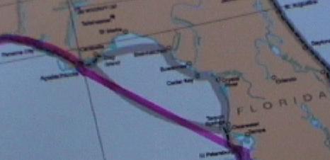
Crossing the corner of the Gulf of Mexico is considerably shorter than following the ICW. However, it also carries a bit more risk, since it is done at night, we'll be subject to the conditions on the gulf, and we'll be over 40 miles from shore for much of the crossing. Some added security on the crossing can come from doing it with one or more other boats. But the down side of this is that they need to be somewhat compatible on schedule and speed. Two years ago Doug and Elaine crossed with two other boats. We didn't see anyone at Apalachicola as a crossing partner, so we're doing this one alone.
The reason for the night crossing is that it is best to have daylight for both the departure and the arrival, since they bring us close to land, a higher density of other watercraft, and other potential obstacles. The crossing distance is 155 nautical miles (times 1.15 for statute miles), measured from the inlet south of Apalachicola. Our speed will be on the order of 9 knots (nautical miles per hour), depending on conditions. This means that the crossing time will be on the order of 17-18 hours. So a late afternoon (daylight) departure would result in a mid morning (daylight) arrival.
It takes most of an hour to cross Apalachicola Bay. This area is smooth and calm. We have great visibility and follow the channel markers to the inlet. Just before the inlet we pass the two markers that can be lined up from the gulf as a guide to safe passage through the inlet. The near marker is 20 feet high and the far one is 36 feet high. This means that a vessel approaching the inlet from the gulf should be able to see one above the other when aligned with the channel.
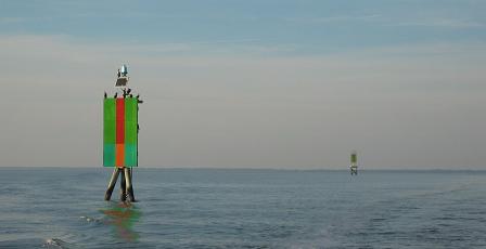
Markers inside Apalachicola inlet
Conditions at our departure from the inlet, at 4:45 PM, were reported as 2-3 foot waves (forecast to decrease to 2 feet). The winds were calm, but forecast to be increasing to 10-15 from the east. Doug offers Jules and me a motion-sickness pill, but we decline. What we experienced initially was nearly calm seas and light winds. This may have been due to the protection of this area represented by St. George islands, through which the inlet was cut.
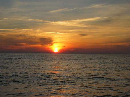
Gulf of Mexico Sunset
Daylight was disappearing and we soon saw Venus in the western sky. When darkness was upon us, we couldn't distinguish the horizon except for being able to see stars. Visibility continued to be very good. Venus was so bright that we saw reflection in the water.
The essential tasks of the person at the helm were 1) try not to run into anything, 2) keep on course, and 3) monitor the engine. The course was about 145 degrees, basically due southeast. Obstacles are a) navigation aids and b) other vessels. We wouldn't have been able to see floating debris. There were only a few nav aids on the course. These are lighted towers maintained by the US Air Force. The first two each had a single flashing white light with about a one second period. Another had a white strobe light.
Boats are required to use navigation lights at night. The standard configuration is three lights: a red on the front port, a green on the front starboard, and a white facing back. Each light illuminates over a 135 degree angle and they must be positioned so that at least one light can be seen from any direction. Since one third of a circle is 120 degrees, this results in a small overlap. In addition, a white light on the mast should be visible all around. Thus, a boat coming directly at us would show a green light on the left, a red light on the right, and a white light above.
The course and the position and track of Bravo! were both indicated on the computer. There would be little, if any, current in the gulf, but the east wind was picking up and would be blowing us to the west of course. So we needed several degrees of crab angle to stay on course. The autopilot was on for the entire crossing, so corrections were made by pressing the +1 or -1 buttons on the panel, generally just once.
The six cylinder Cummins 330 hp. diesel engine performed faultlessly. It maintained 50 psi oil pressure, 180 degrees temperature, and the battery stayed right around 13.5 volts. Doug had replaced the engine oil and filters in Columbus, MS and says that it uses no crankcase oil.
The plan was that one of us would try to sleep while the other two were up. By the time I had my turn sleeping, the waves had grown to 1-2 feet and rather than take my usual upper bunk, I slept on the seat in the galley, which was closer to the center of roll. The natural roll period of Bravo! is about 2-1/2 seconds, so it wasn't a lot different than being rocked in a cradle. I slept very well, and by the time I got up, the moon had risen and we could see the horizon again. Doug had reduced speed slightly to reduce the effects of the waves.
Conditions remained fairly stable throughout the crossing. We tried not to use bright lights in the cabin. Doug had changed the settings in the navigation program in the computer to "Dark", but we still kept the screen down most of the time because of its brightness. He turned off the depth sounder because the gulf is plenty deep and we didn't want the light of the display. We were seeing readings around 70 feet. (The charts in this area indicate depth in fathoms rather than feet.) The light above the instruments has two modes, normal white and dim red for maintaining night vision. About the only reason to turn on the red light is to see the clock.
Moving around, one had to exercise care. The waves and rolling combined to produce a fair amount of movement. There are many handholds strategically placed. We did see many other vessels during the crossing and would try to use binoculars to identify direction of travel, but the movement made that difficult. Of two vessels on a colision course, the one on the right has the right of way. Around 4:00 AM I was at the wheel when a towboat was pushing a barge across our bow from port to starboard. While we would have had the right of way, the distance and relative speeds had the barge well off our course before we got there and neither of us needed to change heading.
Bravo! had been prepared for the crossing by assuring that everything was secured. Doug had tightened the cords holding the bicycles in place on the upper deck. The fenders were stuffed under the dinghy or otherwise secured on the upper deck. The galley table adjusts up and down and had been placed in the full down position. We were careful to keep the water level in the toilet low so it wouldn't slosh out. The bathroom and galley sinks were full of things from the counters so that they wouldn't end up on the floor. We wouldn't be using the galley anyway. There was no dinner on the crossing night, but we munched along the way. At various times, I had an apple, a banana, crackers, etc.
My last sleep started at 5:00 AM and I didn't get up until 8:00. By then we had good daylight and soon were making out the Clearwater skyline. We saw many small fishing boats and also small floats, about 6" diameter, that must be marking traps on the bottom. These are to be avoided so as not to entangle the prop.
Near the bridge over the Clearwater inlet Doug called the Clearwater Municipal Marina on the marine radio to ask about dock space and was given directions. It was Saturday morning and Clearwater Harbor was buzzing. We passed several boats leaving the harbor in the short distance to the marina.
![]()
Entering Clearwater Harbor
We entered the harbor at 10:15 AM, so the crossing had taken 17-1/2 hours. Two years earlier Doug and Elaine had crossed in 16 hours with similar wave heights, probably because they had a following wind. We were happy to be done, but not quite ready to hit the bunks. But more will be covered later.