Bravo! Adventure
December 3 (continued)
Mile 335
We were on the water around 10:00 AM and took only a few minutes to arrive at the dam.
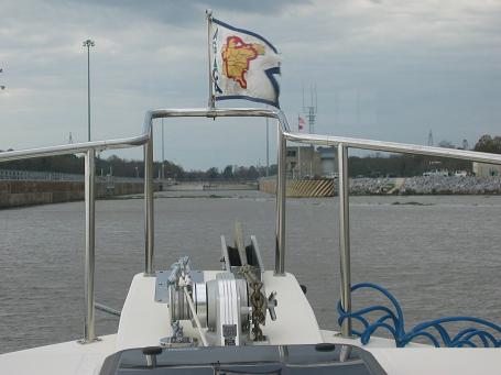
Stennis was the first of five locks that we would pass through on the way to the Gulf of Mexico. The elevation at Columbus is 163 feet above sea level. The lock drops 37 feet. The procedure for locking to make radio contact using marine channel 16. The lock agent asks to change to channel 14 in order to keep 16 clear for monitoring. Identification, location, and request for passage are communicated. The reply gives information on what to expect on other traffic and timing. If the lock is low water, then the bottom gates must be closed and the lock must be filled. Approaching, there is a light that indicates red or, if cleared to enter the lock, green.
We enter the lock alone for this passage, and since the wheel and controls are on the right side of the Bravo! cabin Doug eases us to the right side of the lock where he has better visibility. Doug loops a line just outside the cabin door around a bollard which is recessed into the wall and on tracks so it floats down with us as the water level lowers. The lock is huge; about 600 feet long and our 37 foot boat looks very little. Jules and I have our jobs pushing off at the stern and bow respectively with poles. We have two fenders (small air-filled rubber tanks) that are hanging off the starboard side and a ball near both the front and the back. The upper gates close and the water begins to drain out. There must be about a dozen of these bollards, all descending with the water, and they create a symphony of squeeking. Once down, the doors open and we're on our way. Thanks and best wishes are exchanged on channel 14.
Our destination is Mile 270 where we intend to anchor for the night. So this means that we will be doing 65 miles. Our speed is about 12 miles per hour, so this means a good five hours motoring plus the time to go through the other lock plus we'd like to stop at the visitor center at that lock. So it could be a little tight getting to the anchorage before dark, which is just after 5:00 PM.
We often see no signs of civilization. Then there are the occasional powerline, bridge, or sign alerting us to a buried gasline. There are some areas where homes, mostly summer cottages, are close to the water. Some of these are threatened by erosion, and we see various attempts to keep that at bay. We went many miles before seeing the first person.
Navigation aids include occasional bouys, green on the right and red on the left, to mark the navigable channel or to indicate which fork to take. Also, every mile or two there are are mile markers. They are indicated on the chart as TR (on the left) or SG (on the right) and have the mile number below. TR and SG are triangle red and square green. They often are located at curves and are positioned to be ahear of oncoming traffic. The barges run at night and Doug says that the markers are reflective and well visible at night.
Mile 307
Just before the second lock is the Tom Bevill visitor center. This is an antebellum style mansion of recent construction, the architecture for which was based on three area mansions. The center has various displays relating to the waterway, local wildlife, etc. The commanding view from the observation deck at the top of the mansion included a view of the Montgomery, a steam-powered sternwheeler snagboat used nearly a century ago for clearing debris from the river for safe passage by other craft.
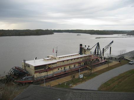
Snagboat Montgomery at Mile 307
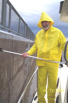
When Doug saw the approaching craft in the background of the picture, he encouraged us along to be able to get lock passage with it. Otherwise, we would have to wait and that would put us late for a daylight arrival at our destination. So we pushed along and joined the other boat in the lock. Rain was starting and Jules and I carried out our duties of pushing off the stern and bow respectively wearing our foul weather gear.
I'll describe other aspects of the river, traffic, wildlife, etc. in a later update, but will note here that we arrived at the place for spending the night just after 5:00 PM. It was getting dark and much later would have caused difficulty in locating the inlet to the side of the waterway. We set the bow anchor and shut down, glad to be off the waterway for the day. Another boat entered the area as we were having dinner (couscous and curried vegetables that Elaine had prepared for us). There was nothing but a boat launch ramp there, so the night was most peaceful.