Bravo! Adventure
December 6
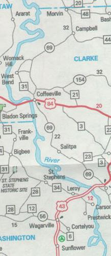
Mile 145
I was awake around 6:45 and heard Doug up, so I got up as well. Dressing in
the top bunk requires a bit of contortionism. The room has just enough space
to be able to stand inside the door and shut it. And the distance from the top
bunk to the ceiling is just under 22". Riki is gone. Doug has had breakfast
and so I help him weigh anchors and we're on our way. Then I catch breakfast
with Jules.
The destination for today is an anchorage in the waterway at a place known as Upper Sunflower Bend Cut-Off at Mile 78.6. We should have no trouble getting there in good daylight. It's 67 miles and we have the last of the five lock passages.
Much of the waterway is on the order of 25-45 feet deep. The general expectation suggested on the charts is for a channel 9' deep by 200' wide. However, we soon encounter an area that is around 70 feet deep, some of the deepest water in the system.
Mile 119
On their way past two years ago, Doug and Elaine stopped at Bobby's Fish Camp.
We stopped with the hope of getting something to eat. Riki was already at the
dock and had taken on fuel. The female of the duo helped us dock just upstream
of their catamaran. We had heard coming in that the restaurant doesn't open
until 3:00 PM, so were resigned to pass on the food. But we did stop at the
office and there was Bobby, roughly in his seventies, in his usual place at
the cash register. The dock was recently replaced, but the rest of the establishment
gave the impression of barely surviving. The fuel is self-serve and we were
planning to top off, but when we got back to the dock Riki was preparing for
departure and we decided to accompany them through the upcoming Coffeeville
Lock. We did have plenty of fuel to get to the next fueling point, in the vicinity
of Mobile Bay.
At Bobby's Fishcamp
Mile 117
It wasn't until we were on our way to the lock that Doug heard that we would
be awaiting the towboat that we had passed earlier. Towboats are much slower,
so that meant a lengthy wait. We were entertained, in part, by the egrets and
herons fishing off the coffer cells near the locks. One egret had a fish that
seemed to be more than it could handle. It would walk from one end to the other
of the log on which it was standing, carrying the fish in its beak.
We took this opportunity to record some of the local dialect. I connected a microphone to my laptop and brought up the U-LAM program, which was designed to collect audio language samples. I positioned the mic near the radio speaker and now have quite a nice sample of Alabama boat pilot and lock operator language.
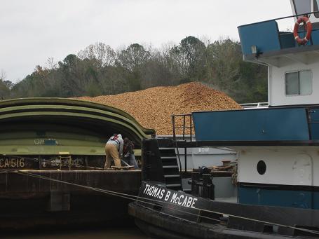
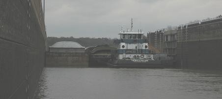
When the Thomas B. McCabe finally arrived at the lock, it went in first. It was three barges wide, taking up about 105' of the 110' lock width. The barges held bark mulch and wood chips. The McCabe pulled forward enough to allow us and Riki to come in behind. We tied to the left wall and Riki to the right. We saw the grunts on the McCabe tightening the cables that lash the towboat to the barges. Apparently the towboat is solidly connected to the barge assembly. There are two independent engine/prop sets, left and right, and the propeller assemblies can be angled to produce side thrust.
When the gates opened at the other end, the towboat was considerate of our relatively small size and made a slow exit. Otherwise, we might have found the backwash from the props difficult.
Below the Coffeeville Lock the water is essentially sea level and is subject to tidal elevation changes. So docking in shallow water at high tide could mean that the boat could be grounded when the tide is low. This means also that the current can go both directions.
Mile 93
Along the way we realize that the GPS is indicating one hour later than our
clocks. So we must have returned to the eastern time zone. We pass under highway
US 43 at mile 93. The next highway bridge will be 71 more miles. This is rural
Alabama.
Mile 78.6
The destination was an unknown. Elaine had made a note in the charts that this
was not a good anchorage. Also, the AGLCA (American Great Loop Cruising Association)
listserve had a posting less than two weeks ago that the site was not available
because of some dredging cable issue. So as we were approaching, we were also
looking for alternative anchorage sites. However, when we got to the site, there
was already one other vessel anchored and no sign of difficulty. So we set both
anchors and settled in for happy hour that included fried spaghetti left over
from last night, thanks to Jules. Riki soon anchored behind us. Dinner was salad
with veggie riblets and baked potatoes. And of course there were more stories
and more of the 31 card game.
The site is in the middle of no where. The clouds that have persisted with us the past few days are covering what would certainly be a glorious sky full of stars and moon. But all we can see is the anchor lights of the two other boats.
Two or three barges have passed since we arrived. I'm not sure how they do this in total darkness. It would seem that their radar will allow only so much.